CAPE WOOLAMAI BEACH
Cape Woolamai beach is known for having consistently serious waves, so consistent the beach was once used to host the Bells Beach Surfing Carnival. Not surprisingly, the beach at Cape Woolamai is extremely popular with surfers.
Catch a wave against the backdrop of ancient pink granite at Cape Woolamai, Phillip Island’s highest point and one of Victoria’s most popular surfing beaches. The region was recently declared a National Surfing Reserve in recognition of its rich surfing heritage and pristine natural environment.
Cape Woolamai Surf Beach is renowned as one of the most consistent and varied surf locations in Australia. The swell is rarely too small to surf and depending on the swell size you can usually find a sheltered break in any wind.
Guests of Bunya By The Sea can walk to the Woolamai Beach Surf Life Saving car park via the beach, about 35 minutes or so. The drive is about 3.5kms or about 6 minutes. If you decide to ride it will take about 12 minutes.
Other Beaches
Discover sheltered bay beaches and wild surf beaches, blowholes, caves and unusual rock formations along Phillip Island’s coastline. Designated a National Surfing Reserve in recognition of its surfing heritage and pristine environment, the island’s diverse coastline boasts some of the best surf breaks in Australia.
Choose the beach to suit your needs on Phillip Island.
Southern surf beaches:
Woolamai Surf Beach
A renowned surf beach with strong rips and currents. This long sandy beach is patrolled by the Woolamai Surf Lifesaving Club during the summer months. Access from Beach Road, off Woolamai Road.
Smiths Beach
Located on a bay and offering gentle surf for less experienced surfers. The beach is patrolled during the summer months. Access from Smiths Beach Road, off Back Beach Road.
YCW Beach
Set on a lovely bay with gentle surf for less experienced surfers. This beach is not patrolled and therefore not recommended for swimming. Access from Beachcomber Avenue, off Back Beach Road.
Surf Beach and Surfies Point
Popular surfing spots not recommended for swimming. Call island surf shops for condition reports. Access from The Esplanade, off Phillip Island Road.
Summerland Beach
The home of the famous nightly Penguin Parade and also a noted surfing beach. There is public access until dusk, when the beach is closed off for the Penguin Parade. This beach is not patrolled by lifesavers. Access from Ventnor Road.
Northern bay beaches:
Shelly Beach, Cat Bay Beach, Flynns Reef
Shelly Beach is good for beginner surfers, as waves are seldom over one metre in size. Cat Bay Beach and Flynns Beach have waves breaking over flat rock and reef. These beaches are not patrolled by lifesavers. Access from Ventnor Road.
Ventnor Beach, Anchorage Beach
Good swimming beaches with stunning coastal views of Phillip Island and the Mornington Peninsula. Not suitable for surfing and not patrolled by lifesavers. Access from Ventnor Beach Road, off Ventnor Road.
Cape Woolamai Walk
Guests of Bunya By The Sea who are feeling adventurous can walk to the Woolamai Beach Surf Life Saving car park to commence the Cape Woolamai walk. Estimated walk time from Bunya By The Sea via the beach, about 35 minutes or so. The drive is about 3.5kms or about 6 minutes. If you decide to ride it will take about 12 minutes.
When walking, there’s a short trail from the beach that cuts over to the Woolamai Surf Beach parking.
From Woolamai Beach car park, walk onto beach, turn left, follow beach for approximately 1km, take stairs up to clifftop to loop walks.
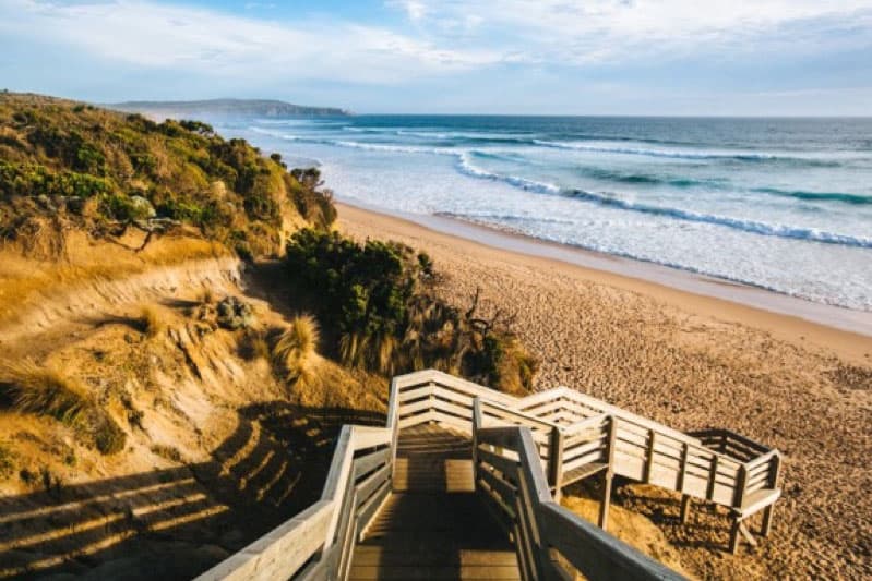
Commencing at the information shelter take the wooden ramp down to the beach and walking southeast along a wide strip of sand toward a rocky point that juts out from Cape Woolamai. After 700 meters, and before reaching the end of the beach, you will spot a wooden staircase on the left. Take it up onto the sandy grass-covered bluffs that connect the rocky end of Cape Woolamai with the rest of Phillip Island.
At the top of the steps, there is a sign for the Cape Woolamai Walking Trails directing you to turn right (the service road to the left heads back to the parking area). The trail sign highlights three of the hiking possibilities on Cape Woolamai, each with an identifying color that is used on markers along the trail. The hike described here actually borrows a bit from all three.
Walk along the sheer cliff tops of Phillip Island’s most southerly point and be rewarded with superb panoramas of the island. Cape Woolamai is the highest point on Phillip Island and is also the largest shearwater rookery (mutton birds). Watch the daring surfers in action down on nearby Woolamai Surf Beach and keep an eye out for the burrows of the short-tailed shearwaters, small migratory birds that fly to Alaska each April.

Explore the full Cape Woolamai Circuit, a combination of all three Cape Woolamai walking tracks, or try something a little shorter. All walks start from the information shelter at the carpark and follow the beach to the left for approximately 1-kilometre.
Pinnacles walk (green markers) This track is approximately 4 kilometres in length with an estimated walking time of 2 hours return.
Old Granite Quarry Walk (blue markers) This walk is approximately 6 kilometres in length with an estimated walking time of 3 hours return.
Cape Woolamai Beacon Walk (black markers) This route is approximately 6.6 kilometres in length with an estimated walking time of 3.5 hours return.
Track: Good Grade: Level 2 – No experience required.
The track is hardened gravel or compacted surface and may have a gentle hill section or sections and some steps. Walks up to 10km.
Start: Cape Woolamai Surf Lifesaving Club car park
Finish: Cape Woolamai Surf Lifesaving Club car park
Max elevation: 104 m
Min elevation: 1 m
Total climbing: 237 m
Total descent: -238 m

Note: If you want to photograph the Pinnacles (below) landmark, the best time is either in the morning or at sunset.

CHURCHILL ISLAND WALK
Churchill Island is the perfect place for a walk with small children. Only a 7 minute drive (3.4kms) from Bunya By The Sea. Guests can also walk in about 25 minutes or so. Even better, take the bikes and it will only take about 12 minutes.
Accessible via a narrow bridge from Newhaven on Phillip Island. If you are lucky you will see lambs frolicking and cattle grazing in the paddocks as you drive to the parking area. Kids love it! Look out for Cape Barren Geese and their chicks.
Access the Island loop walks from the top LHS of the carpark or from the RHS of the lavender field behind the Visitor Centre. Walk maps are available at the information centre.
History First walked by Boonwurrung Aboriginal people, Churchill Island now has an important place in the history of European settlement in Victoria. Lt. James Grant disembarked from the Lady Nelson in 1801 and named the island after the man who had given him seeds that he planted, making Churchill Island the site of the first European agricultural pursuits in Victoria. Since the 1850s this fertile 57 hectare island has been continuously farmed and in 1872 when Samuel Amess, former Mayor of Melbourne, purchased the island for both holiday and farming use, he built a substantial house and outbuildings.
The historical buildings and remnants of historical gardens are now a drawcard for tens of thousands of visitors a year. An historical curator is presently documenting remaining artefacts.
Location: Visitor Information Centre, Churchill Island, Churchill Island, Churchill Island, Victoria
Grade: Medium,
Time: Island Loop – 2hrs, North Point Loop – 1hr
Distance: Island Loop – 5km, North Point Loop – 2km
Facilities: Toilets, Baby change, Disabled access, Drinking water, Parking, Cafe, Information centre, Toilets, Baby change, Disabled access, Cafe, Parking, Information centre, Picnic table
There is an admission fee to the Historic Homestead and Heritage Farm which features farming demonstrations like milking a cow and working dogs.
Churchill Island opening hours: Daily 10am – 5pm